Irian Jaya 1992
DUTCH CAVING EXPEDITION TO IRIAN JAYA – INDONESIA
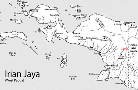
In 1989 members of the Dutch Speleological Association, Speleo Nederland , considered an expedition to Indonesia. Irian Jaya and the land of the Maluku Islands were their favourite area's. After having made contact with mr. dr. Robbie King Ko, president of the Indonesian speleological organisation, Finspac, opportunities to explore u own caves in Indonesia seemed endless. During the literature studies for the proposed expedition a book of a Dutch scientific expedition to the inland of Irian Jay a was found (Brongersma and Venema, 1960). This expedition spend nearly a year doing all kinds of research, especially in the field of anthropology in the valley of the Oksibil-river. This valley is situated on the region on the Starmountains near the border of Papua New Guinea. The geologist Verstappen who joined the expedition described all kinds of karst phenomena. Especially interesting was a dye-test he preformed at what he thought to be the sink of the Oksibil-river . About 4 hours later the coloured water appeared in a source on the west bank of the Digul-river. The water passed through the limestone beds for 11 kilometres. The difference in height between the sink and the source was about 800 metres. Because this information became available to us the exploration of the Oksibil-valley became the primary goal of this speleological expedition. The eastern part of the well known Baliem-valley was considered as an alternative in Irian Jaya.
Sixteen members of Speleo Nederland spent two month (between june and august 1992) in the Oksibil-valley prospecting and exploring caves from out the basecamp in Mabilabol. To get permits to visit the Oksibil-valley seemed to be a difficult task. Two visits to Indonesia prior to the expedition and good contacts with local people and authorities finally resulted in the documents necessary. Transport from Jayapura (capital of Irian Jaya at the northern coast) to the Oksibil-valley was realised by chartering a Twin-otter plane from the domestic flight company Merpati. All other air-transport was arranged by AMA, the Associated Mission Aviation company. Because of unfavourable weather conditions flights couldn't take place on a regular basis. Seven flights were necessary to get all people and equipment back to the coast again. The people from AMA also took care of communication with the Netherlands. Due to unclear and time-consuming custom procedures in Indonesia, the satellite-communication system which was sent from Amsterdam Airport, could not enter the country. The speleological equipment on the other hand presented us with no problems and reached the Oksibil-valley without any delay. Carbide, food and parts of the cooking utensils were bought in Jayapura. Only a limited amount of goods could be bought in the Oksibil-valley. Most of the time locally available food was used, the diets mainly cons isted of sweet potatoes (boneng) and several kinds of vegetables. During trips in the jungle the menu was papua like, beside boneng also khuskhus, bats and insects were regular eaten. Chicken and pig were only eaten twice on a special occasion. Due to the efforts of the Dutch priest, Pater Kees' and the head of the local school John Sasaka a modest house big enough for 16 people could be used as a basecamp in Mabilabol. Shelters would not hav e been very comfortable in the rainy climate of Irian Jaya. During trips in the jungle simple huts were built by our guides. Erecting tents was not possible in the jungle. Largely because of the cooperation of Pater Kees, a group of 18 Ngalum men were prepared to guide us to cave entrances. Pater Kees his knowledge of the Ngalum, their language and traditions was essential to the success of the expedition. The Ngalum have a traditional belief in which caves play an important role. Caves were made by their forefathers by means of a knife made of bone of the casuaris-bird. The caves were needed to drain the water which floated the valley. Besides that, demons and spirits live in caves and travel through passages under ground. Before entering a cave these spirits were pacified by a magic spell or a prayer spoken by our guides, so we wouldn't disturb them by entering their cave. Particular aspects that need much consideration are the climate and weather of Irian Jaya in general and of the Oksibil-valley in particular. The enormous amounts of rain make most of the caves dangerous. Nearly all of them are in some way or another a sink. Especially the sink of the Oksibil- river, Sibil Buk 1 can be considered as extremely dangerous. Not only because of the amount of water, but also because of the level in the Oksibil- river may rise unexpectedly and very rapid. Rain statistics have been collected during the Brongersma Expedition in 1959 and the last ten years by the mission. During the speleological expedition a scale was placed in the river to indicate the water level. The level was compared with the amount of local rain. It turned out that there is hardly any relation between these date. The Ngalum stated that heavy rains in a region west from the Oksibil-valley may cause sudden rise of the water level which is called banjir (wall of water). This happened once during a cave exploration which caused a narrow escape of four cavers who were in Sibil Buk 1 at that moment. No reports of cave explorations of previous expeditions in the Oksibil-valley were found during the preparations. However it turned out that some Japanese students, interested in caves visited the valley one year before. They did indeed visit some caves (Atem Buk 1" T aladol Buk V) but systematic exploration and publication did not take place as we know. A GPS-device (Global Positioning System), to locate exactly the cave entrances was not available during our expedition. Coordinates couldn' t be defIned because of dense vegetation, clouds and bad maps of the area. The local names of the entrances were used in the descriptions and maps. With the help of these names and the Ngalum it is possible to refind the entrances. Some caves were situated in relation to Mabilabol using ordinary cave-surveying techniques (figure 5.1). More than 80 caves with a total length of nearly 5 kilometres, were explored during this expedition, varying from only a few metres deep or long up to Sibil Buk 1 with a length of 2313 meters and a depth of 349 meters. Most of the information of the different caves can be get from the many survey' s. Therefor only the most interesting caves and the conclusion are described below. The region that is explored by this expedition is arbitrarily divided into 5 area's.
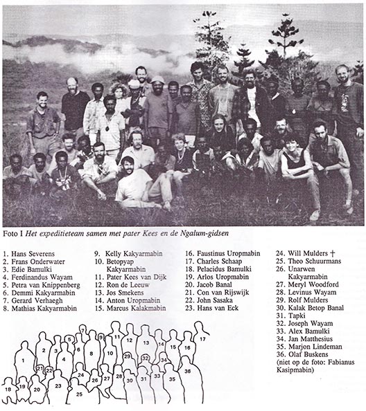
The Expeditionteam:
The Explorationarea’s
1) The southern flank of the Oksibil-valley
Taladol Buk 111: recently Pater Kees let us know that this cave did collapse.
Taladol Buk V. the beautiful entrance pitch is diffIcult to rig because of the soft limestone. At the top of the P 11 a bolt of the Japanese students was found. The meander in the deepest part gets to narrow to allow further explorations, despite a faintly air current that can be noticed. Taladol Buk VII : the walls of the fIrst pitch will have its diffIculties during rainfall. Beyond the second pitch no more water is encountered.
Ongsiringki Buk series: just like the Taladol Buk series the caves have an arbitrary number to distinguish them. The Ngalum believe that they are connected underground of which we couldn't find any proof.
Tulotum Buk 11: Probably a few hundred bats stay in this cave.
Hard conclusions about the 26 entrances in the area of the southern flank of the Oksibil-valley are difficult to draw. Most caves have a south-east orientation and will carry of water during periods of rain. One of the interesting things is that some caves, for example Taladol Buk V continue deeper than the altitude of the Oksibil-river itself.
2) The northern flank of the Oksibil-valley.
16 caves were explored here, but they were all relatively small and ended after one or two pitches. Most of these caves drain water during rainfall. No conclusions can be drawn with reference to the hydrology of this area. Absam Buk: After the second pitch P75 a narrow meander continued but wasn't thoroughly examined because of lack of time.
Buk Without Name 11: one of the few caves that was found near Mabilabol without the help of the Ngalum during the first few day s during our stay. Human remains were found about 5 skeletons, which indicates that the cave was formerly used as burial side.
Sibil Buk area east from Mabilabol. Blackies pot was discovered by one of the dogs from Pater Kees. Black fell down the pitch and didn't survive the discovery.
Adbon Buk: nearly one kilometre of passages was explored in Adbon Buk. The entrance lies only 16 metres from and 1.5 meters above the Oksibil-river.The cave itself lies well below the water level and must be considered as dangerous in case of a rise in the water level. The humerus inlets of the lower regions of the cave are evident of this. In some parts of the cave beautiful lime- stone formations are present. Because of the danger of flooding the explorations to the deepest point in the cave was halted. The final passage in the cave in only one metre square in size and the walls are polished by the force of the passing water.
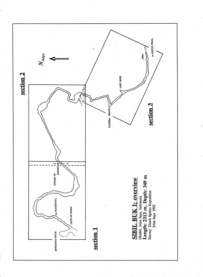
Sibil Buk 1: during the expedition of 1959 the point where the Oksibil-river was considered to disappear under ground was a hole of 3 x 3 metres. However, the real entrance of the cave is somewhat larger. 57 metres high and more than 15 metres wide. This point can be reached by descending the 176 metres entrance doline. At the bottom of the doline the river is met once again. A highwater level line can be noticed several meters above the riverbed which indicates the enormous amounts of water during a banjir. Once inside Sibil Buk 1 the ceiling can't be seen any more and the dimensions stay enormous. A bivouac was made out of reach of the water above the P16 (cosy corner). Only at a few places in Sibil Buk 1 it is possible to be out of the water during a banjir. Further into the cave more swimming is required. At a depth of 349 metres, after 2.3 kilometres from the top of the entrance pitch the deepest point , First Dutch Final' was reached. Still Sibil Buk 1 continues with it's enormous dimensions. Without any possibility to warn cavers inside for a banjir, it is to dangerous to go on.
Sibil Buk 11 : This cave doesn't have any relation with no. 1, but lies in the same area.
4) Tamal Buk area south of Mabilabol.
This area lies one day walking south of Mabilabol. The Ngalum explained that there is no surface river in the area and all the water is disappearing into caves. So we suspect the presence of an underground river. Nineteen caves were descended in this area of which the deepest is about 80 metres. All the caves are probably dangerous during rainfall. None of the them continued in one way or another, none of them gave access to an underground river .
5) Atem Buk area west of Mabilabol.
Two rivers flow in this area, Ok Atem and Ok Aisjek, which join and continues as Ok Atem before disappearing underground . Atem Buk 1: the sink of Ok, Atem is a doline, completely fllled with water. A small passage can be entered which after several metres is fllled with water. This water is not related to the nearby Oksibil- river. The Ngalum believe that the underground river crosses the surface river and has a relationship with the caves on the southern flank of the Oksibil-valley. No evidence of this claim could be found. In total 65 % of the expedition time was spent in the Oksibil-valley. Still there's a lot of work to be done in this region. Sibil Buk 1 is of course the main project for a next expedition. This time four of our team were surprised by a banjir in this enormous cave system. Only luck prevented them from drowning. An early warning system for a banjir is necessary to prevent future accidents, because the weather and the waterlevel of the Oksibil-river are completely unpredictable.
For a compleet expeditionreport you can clic on the expeditionreport down below
NEDERLANDSE SPELEOLOGISCHE EXPEDITIE NAAR IRIAN JAYA
In het algemeen kan met tevredenheid worden teruggekeken op bet verloop en de resultaten van deze expeditie. Het feit dat 65 % van het totaal aantal mandagen in de Oksibil-vallei is gewerkt, is voor een dergelijk moeilijk toegankelijk gebied een prestatie op zich. De contacten en de samenwerking met pater Kees en de Ngalum overtroffen alle verwachtingen. Dit is in grote mate bepalend geweest voor bet succes van de expeditie. De doelstelling een inventarisatie te maken van de speleologische fenomenen in het gebied rond de Oksibil-vallei is in ruime mate gehaald. Ruim 80 grotten werden tijdens de expeditie ontdekt en getopografeerd. Hierbij varieerden de afmetingen van slechts enkele meters lengte en diepte tot de opgemeten lengte van 2313 meter en 349 meter diepte van Sibil Buk 1.
De totale lengte aan ondergrondse passages die door de expeditieleden werd opgemeten bedraagt bijna vijf kilometer. Met de wetenschap dat het bereiken van de ingangen vaak al een behoorlijke inspanning vergde, mag dit zonder meer een goed resultaat genoemd worden. Er blijft echter in het gebied rond de Oksibil-vallei nog genoeg te doen. Alleen de gebieden die relatief dicht bij het basiskamp in Mabilabol lagen zijn wat de grotten betreft volledig bekeken. Meerdaagse tochten met kleinere kampen naar verdere gebieden zullen ongetwijfeld nog een schat aan ondergrondse mogelijkheden bieden. Verder ten noorden en westen van de Oksibil-vallei zijn niet of nauwelijks prospectietochten ondernomen. Het gebied dat zich boven de tot nu toe bekende loop van Sibil Buk 1 bevindt is zeker de moeite van bet prospecteren waard. Gezien het aantal plaatsen in deze grot zelf waar water hoog uit de wanden naar binnen stroomt, is het waarschijnlijk dat bovengronds verdwijngaten te vinden zijn. Echter, door gebrek aan tijd en de tijdelijke afwezigheid van een gids die dat gebied op zijn duimpje kende, zijn we er niet aan toe gekomen hier verder te zoeken. Ook zijn er grotten die niet tot in alle uithoeken zijn bekeken of waar vanwege de gevaarlijke situatie in geval van hoog water voortijdig werd teruggegaan. Adbon Buk is hiervan een goed voorbeeld ; hier werd een kilometer aan gangen gevonden die een labyrint-achtig verloop kennen en waarbij het diepst bereikte punt nog niet het einde van de grot was.
Dit laatste geldt ook voor het punt First Dutch Final van Sibil Buk 1. Deze grot is echter evenals Adbon Buk levensgevaarlijk in het geval van hoog water. Gezien het klimaat in het gebied en de onvoorspelbaarheid van de waterstand van de Oksibil-rivier, is het onverantwoord hier zonder uitgebreide voorzorgsmaatregelen verder te gaan. Om Sibil Buk 1 op een veilige manier verder te verkennen is het noodzakelijk eventueel snel stijgend water of zelfs een banjir voor te kunnen zijn. Het anti-crue, oftewel het buiten het bereik van het water uithangen van koord, is een mogelijkheid, maar zal (te) veel mankracht en middelen kosten. Om het punt, First Dutch Final' te bereiken zou er enkele kilometers koord hoog in de wanden moeten worden uitgehangen. Het realiseren van vluchtroutes op alleen de gevaarlijkste stukken van de grot zou eventueel mogelijk zijn, maar werkt niet echt bij een banjir die onverwacht komt aanstormen. Men wordt dan eenvoudig door het water verrast en is geen vlucht meer mogelijk. Een waarschuwingssysteem, dat tijdig de speleologen die op dat moment in Sibil Buk 1 zijn, informeert over aanstormende watermassa's, is een methode om veilig verder te kunnen gaan in de grot. Een vluchttijd van enkele uren is dan gewenst. Daarvoor is de afstand tussen Mabilabol en de ingang van Sibil Buk 1 te klein. Er zou een peilstok kilometers stroomopwaarts in de rivier moeten worden geplaatst die permanent bewaakt wordt. Met behulp van radioapparatuur zou een bericht van opkomend water moeten worden doorgegeven naar de ingang. De speleologen ondergronds kunnen dan via telefoon of een draadloze verbinding gewaarschuwd worden. Pas dan is er tijd genoeg om een veilige plaats op te kunnen zoeken in de grot zelf. Geduldig wachten tot het water weer zakt is dan het enige wat de ingesloten speleologen kunnen doen. Met betrekking tot de doelstelling het verdwijnpunt van de Oksibil-rivier te onderzoeken kan gesteld worden dat daar in zekere mate aan is voldaan. Ruim twee kilometer in kaart brengen van een dergelijke grot is een goede prestatie. Sibi1 Buk 1 heeft echter laten zien hoe gevaarlijk de grot is , waarbij vier speleologen door het oog van de naald kropen. De benaming, "First Dutch Final" impliceert dat bet karwei nog niet geklaard is. Er zal een methode moeten worden uitgedacht om de onvoorspelbaarheid en de kracht van een banjir te slim af te kunnen zijn.